History of Clarinda, Oakleigh South and Clayton South
Clarinda, Oakleigh South and Clayton South (incorporating the neighbourhood of Westall) are the northernmost suburbs of the City of Kingston in south-eastern Melbourne. This is a largely suburban residential area, dotted with large tracts of industry and nestled between Warrigal, Centre, Westall and Heatherton Roads. Two golf courses and large parks such as Namitjira, Bald Hill, The Grange and Heatherton provide a number of green refuges. In the southern part of the area, along Heatherton and Old Dandenong Roads, a smattering of market gardens remain - a reminder of the neighbourhood’s recent past.
The area of land where these suburbs now lie has undergone two periods of significant change during the last 200 years. The first was the gradual transformation of the natural heathland by graziers, agriculturalists and sand miners. The second period was the change from rural to residential and industrial development. As the environment evolved, the people living on the land also changed, reflecting and responding to developments occurring throughout Melbourne and Australia.
The Bunurong
The land now occupied by Clayton South, Oakleigh South and Clarinda was originally coastal heathland. Vegetation was low and scrubby, about one metre high with intermittent stands of small acacia and red gums.
The land was claimed and intermittently occupied by the Yalukit-willam clan of the Bunurong tribe who occupied a strip of coastal land north of Mordialloc Creek. Other clans of the Bunurong tribe lived south of the creek through to the Mornington Peninsula. Further inland lived the Wurundjeri-baluk clan of the Woiworung tribe. All these people belonged to a nation of Aboriginal people known as the Kulin who occupied most of Western and Central Victoria.
The Bunurong people roamed the area with campsites and activities dependent on the seasons. In good weather they camped along the seashore while in poor weather they sought shelter in woodland or near rocks. Traditional Aboriginal lifestyle in coastal areas of Port Phillip was influenced by contact with sealers and whalers for many decades before the foundation of Melbourne. However, occupation of the Port Phillip region in the early nineteenth century had a profound effect on Aborigines in the area. Disease, violent conflict, disruption of food sources by people and stock and the destruction of camping and meeting places all resulted in the severe disruption of aboriginal lifestyle and the disastrous decline in birth-rate. In the first 27 years following the foundation of Melbourne the numbers of Bunurong and their neighbouring tribe, the Woiworung, fell from approximately 207 people to only 28. Although today there are many aboriginal people living in Melbourne who are actively involved in rediscovering Bunurong ways of life, traditional aboriginal lifestyle as practiced by people before European contact, died with the death of the Bunurong people in the nineteenth century.
Death of the Heathland
The first European to occupy this area was John O’Shannessy who took a licence for a squatting run of 40,000 acres in the early 1840s. This run included land that is now Clarinda, Clayton South, Dingley and Heatherton. In 1846 O’Shannessy passed his licence to John and Richard King who, for the next few years, ran sheep and cattle and employed Irish settlers to clear the heathland.
In the early 1850s, the government of the colony of Victoria revoked squatters’ licences. The old squatting runs were divided and land auctioned to selectors. These auctions were the beginning of extensive European settlement in the area and the gradual transformation of heathland into farmland.
Between 1852 and 1856, small farmers, land speculators and market gardeners bought parcels of land and slowly cleared the scrub and cultivated the soil. In the second half of the nineteenth century the cost of vegetables in Melbourne was high and market gardening on the fringes of the city was a good way to make a living. For the next 100 years Oakleigh South, Clarinda and Clayton South were part of one of the largest horticultural districts in Victoria, producing large quantities of vegetables for Melbourne.
From its earliest days, the area attracted new settlers to Australia. The squatters John and Richard King, themselves Irishmen, were members of an organisation called The Southern Irishmen, which sponsored Irish immigration to Victoria. Many new Irish settlers came to live in the vicinity of the Kings’ run, in the areas that are now East Bentleigh and Oakleigh South. Many of the early settlers to the Clarinda area (originally called ‘Bald Hill’) were people newly arrived from Scotland.
During this time, settlement in south-eastern Melbourne was largely confined to the fringes of the bay. Dandenong was still a country town and Springvale was a scattering of houses. Although much of the heathland in the area now occupied by Clayton South, Oakleigh South and Clarinda was cleared to make way for farms, the area remained sparsely settled. Tracts of scrub and heath remained and access to the neighbouring townships of Moorabbin, Oakleigh and Dandenong was by sandy bush tracks.
The completion of the Oakleigh-Dandenong rail line in 1877 increased access to the north-eastern part of the area. Railway stations were built at Clayton and Springvale in 1883 and 1884 and blocks of land were sold in the vicinity of these stations. Subdivisions gradually spread south from the cluster settlement around the Clayton station and west from the embryonic township of Springvale - although the focus of settlement remained around the railway stations.
In 1889 the ‘Clayton Vale’ subdivision, west of Westall Road (in the area now known as Westall and named after the local market gardener Thomas Westall), was advertised for sale. Land was reserved for a railway station and, in an attempt to attract upstanding British citizens, the streets were named after English writers such as Wordsworth, Tennyson, Milton and Browning. These streets remain and the area is still known, ironically, as ‘Poets Corner’. However, the Clayton Vale subdivision was not a successful development in the 1880s and only a few small parcels of land were purchased by a few enterprising growers of ornamental flowers.
Burgeoning Suburbia
During the first half of the twentieth century Clayton South, Oakleigh South and Clarinda remained a sparsely settled area of market gardens and small farms. Although residential areas were slowly developing in the northern part of the area (off Centre Road) and there were scattered facilities such as primary schools (opened at Bald Hills in 1899 and Clayton South in 1929), the neighbourhood remained a fringe settlement for Springvale to the East and Clayton to the North.
During the decades following the end of the Second World War Melbourne burst its borders and flowed into semi rural land. Moorabbin and Oakleigh rapidly expanded drawing in the northern part of Clarinda and the western part of South Oakleigh. New residential streets were laid, houses constructed and services laid. Although often services such as drainage, sewerage and road surfacing came many months after the occupation of housing, creating the notorious ‘heartbreak’ streets of the late 1950s.
Rapid suburban expansion in the 1950s and 1960s was a reaction against the almost complete stagnation of the building industry during the war and the depression of the 1930s. This combined with attitudinal changes, which emphasised ideals of home ownership, space and affordable car ownership, which made life in suburbia an attractive proposition for Melburnians.
Yet it was changes in the industrial and demographic environment of Melbourne, which most dramatically transformed the landscape of the Clayton South, Clarinda, Oakleigh South. In the three decades following the Second World War, Melbourne industries decentralised, relocating from the inner suburbs to the fringes of suburbia where land was cheap and there was more space for the construction of modern factories. Manufacturing industries relocated to a series of outer suburban belts strung along major rail and road routes. One major belt flowed through Oakleigh, Moorabbin, Mulgrave, Clayton and Springvale to Dandenong, an area that incorporated Clarinda and Clayton South. One of the earliest companies to build in the area was Phillips Industries, which purchased a large block of land between Clarinda and Carrol Roads. Volkswagon also built on land west of Westall Road. While the industries themselves have come and gone, Clarinda remains part of this larger industrial belt.
The growth of industry brought more housing development. With nearby factories providing employment, Clayton South and Oakleigh South suddenly became convenient and relatively cheap places to live.
The Changing Face of the Australian People
Another significant development in post-war Australia was the increase and changing nature of immigration. This had a profound effect on Australian society and equally on the development of the suburbs of Clayton South, Oakleigh South and Clarinda.
During the first half of the twentieth century Australian immigration was dominated by the White Australia Policy. Passed in 1901 the policy remained in force until after the Second World War. It was gradually eroded during the 1950s and 1960s and finally buried by the Whitlam government in the early 1970s. The policy, through the infamous dictation test as well as other less crude methods, excluded all but British, Irish, Northern Europeans and a small number of privileged migrants from other countries until the late 1940s. Almost all migrants arriving in Australia before the Second World War were from Britain or Ireland.
After the Second World War the attitudes of Australian governments changed. In 1945 Australia had a population of only seven million and many people felt there was an urgent need to increase the population to maintain growth in the country and as an insurance against invasion. Although half of the migrants to Australia still came from Britain during the 1950s and 1960s, the Australian government formed agreements with many European countries and actively encouraged immigrants from southern as well as northern Europe. Large numbers of people from Italy and Greece, Malta, Turkey, Yugoslavia, Holland and Germany as well as Indians and Sri Lankans of European descent came to settle in Australia, in most cases to live in Sydney and Melbourne. The Australian government encouraged workers from occupations where there was a scarcity in Australia. It particularly encouraged workers with families who would contribute to the total population of the country. Thus began a process of chain migration, particularly of Greek and Italian families, which continued until the early 1970s.
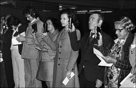
Citizenship ceremony at St. Kilda Town Hall, Melbourne, 1974. Photograph, courtesy of the Department of Immigration and Multicultural Affairs Photographic Archive.
Many southern European migrants settled first in Melbourne’s inner suburbs such as Carlton and Brunswick. But as they became more financially established, and more family and friends arrived, many sought to purchase or build larger homes. Land in developing suburbs such as Oakleigh South, Clayton South and Clarinda provided an ideal opportunity for larger house blocks. Many people chose to build their own houses and local industries provided employment for many of the first generation of Greek and Italian settlers.
As late as the early 1980s, large tracts of land in Clayton South, Oakleigh South and Clarinda remained as either market gardens, rough vacant land awaiting development or sand quarries. One of the last residential subdivisions was in the area around Bourke Road, most of which was settled in the late 1970s. The early residents in each subdivision experienced a wilderness of services and facilities but as houses were built and occupied, schools, shops, child health centres and some public transport was gradually constructed. The high school at Westall opened in 1963 and became a focal point for the Clayton South community. Many of the new settlers also developed their own social supports in the form of places of worship, shops and community groups.
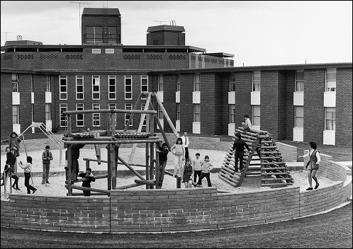
Children in the playground at Enterprise, Springvale, Melbourne, 1971. Photograph, courtesy of the Department of Immigration and Multicultural Affairs Photographic Archive.
The Commonwealth Government Enterprise Migrant Centre opened in 1970 in Springvale, on the border of Clayton South. The migrant centre was one of a number of hostels located in newer suburbs of Melbourne. It provided accommodation, food and welfare, housing and employment advise to migrants, mainly refugees, who had just arrived in the country. It also provided a stable and assisted environment from which new migrants could find homes and employment. Most people stayed for six to twelve months before moving into private rental or public housing and three quarters of the residents moved into the neighbouring suburbs of Springvale and Clayton South.
The hostel, and therefore the surrounding suburbs, accepted refugees from many parts of the world. In 1971 most residents in the hostel came from the Yugoslav states. By 1974 the largest group was from South America and in 1975 the hostel became home to many East Timorese. The first group of Vietnamese refugees arrived at the Enterprise hostel in December 1977. During the late 1980s, and prior to the hostel closing in the early 1990s, people from North Africa were also accommodated there.
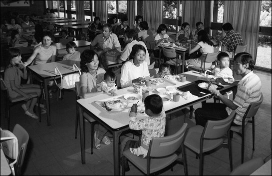
Dining room of the migrant accommodation centre at Enterprise, Springvale, Melbourne, 1984. Photograph, courtesy of the Department of Immigration and Multicultural Affairs Photographic Archive.
Springvale and Clayton South also became home to a large number of Vietnamese refugees. They established welfare and social associations and places of worship and Vietnamese shops burgeoned along Springvale Road. This area also attracted many people from Laos, Cambodia, China and other parts of Asia. While many Cambodian, Vietnamese and Chinese lived in Clayton South, most looked to Springvale as having the social infrastructure of their community.
The people living in the northern part of Clarinda and Clayton South, however, congregate at the Clayton shops while the neighbouring suburb of Oakleigh has become a centre for the Greek community. The ‘semi-rural’ belt of market gardens, tips, golf courses and industrial land along Old Dandenong and Heatherton roads continues to provide a physical and psychological barrier between this area and the rest of the City of Kingston
The suburbs of Clayton South, Oakleigh South and Clarinda are now home to more than 23,000 people, with over 57% of residents born outside Australia. Of the 43% of residents who were born in Australia, a significant proportion of these are children of people born overseas. The largest communities in the area are people from Greece, Vietnam, Italy, India and Sri Lanka. There are also significant numbers of people from the United Kingdom and Ireland, Philippines, China, Eastern Europe and the former Soviet Union, Cambodia, Chile, Northern Africa, the Middle East and the Pacific Islands.
As our nation celebrates its centenary, we should also celebrate Clayton South, Clarinda and Oakleigh South, one of the most culturally diverse and harmonious communities in Australia.
